


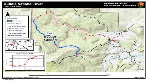
Image: A topographic map of the Cecil Cove Loop. The open section of trail from the Cecil Creek Trailhead to the Jones Cemetery is indicated by a red dashed line. The closed section from the Jones Cemetery to the Compton-Erbie Road is indicated by a solid blue line. Gravel roads are indicated by solid black lines. (NPS)
A temporary closure has been established within the Buffalo National River National Park on the upper section of the Cecil Cove Trail from the Jones Cemetery to the intersection with the Compton-Erbie Road. The lower section from the Cecil Cove Trailhead to the Jones Cemetery will remain open.
In the fall of 2020, a large landslide occurred on the upper ridge of the Cecil Cove Trail. This landslide was reported to National Park Service (NPS) staff by an Adopt-A-Trail program volunteer in November 2020.
Since the report, NPS crews have visited and reassessed the slide monthly. Crews say the site is extremely unstable, and it continues to move. This has caused unstable soil, trees and loose rock hazards along that part of the trail.
Due to the instability of the area and without any known safe alternate routes, this section of the Cecil Cove Trail will be closed until it can be deemed safe. Updates will be posted on the NPS website: https://www.nps.gov/buff/planyourvisit/conditions.htm
WebReadyTM Powered by WireReady® NSI