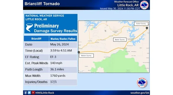
The National Weather Service in North Little Rock has finished their surveys of the damage done by Sunday morning’s storms in northern central Arkansas and updated the path of the tornado the struck the Briarcliff and Salesville area. The weather service is calling the tornado the “Briarcliff” tornado and says after a more detailed ground survey and satellite imagery, they have determined the tornado had a track of 36.1 miles, starting south of Yellville in Marion County and ending in Fulton County near Elizabeth.One death and 17 injuries were reported from this particular tornado Sunday morning. The weather service estimates it was on the ground nearly one hour, beginning at 3:59 and ending at 4:51.
The tornado has been rated an EF3 with estimated peak winds of 140 miles-per-hour and maximum width of 1,760 yards, or one mile.
The tornado began just west of Arkansas State Highway 14 on Marion County Road 5002 near Abbey Lane, snapping and uprooting trees.
The tornado continued across Highway 14 to Marion County Road 6014 and 6011 where it caused minor roof damage to some homes and continued to snap and uproot trees. On Backway road, a double-wide mobile home shifted off its foundation a few feet and had a large tree fall on it. Across the street, an outbuilding sustained damage to the roof and flooring.
The tornado continued towards Hand Mountain where the width widened significantly as it snapped and uprooted numerous trees and crossed the White River.
The tornado then moved into a subdivision along the White River, pulling siding and shingles off houses in addition to causing significant tree damage.
The tornado then continued across Shipps Ferry Road and Round Rock Trail snapping and uprooting additional trees.
As it approached the Arkana area, large swaths of trees were found uprooted and snapped as it crossed the White River briefly once again north of Hwy 341 at Riverside Drive.
The tornado continued towards Briarcliff, where mostly tree damage was observed to the west of State Highway 5.
As the tornado crossed the highway, widespread tree damage became prevalent, with most trees snapped at their trunks. A few structures were severely damaged, including a home, and a metal shop building. The tornado also impacted a local RV/trailer camping park, where five fifth-wheel recreation trailers were tossed and completely destroyed. One fatality was reported out of this area as well.
The tornado then began to move northward, crossing over a 350 kV transmission line, snapping several wooden two-poled line towers, and bending two steel two-poled line towers to the ground, indicative of EF2 wind speeds.
After crossing highway 5, the tornado moved into the Briarcliff residential area, encountering significant topography. Seventeen injuries were reported within the Briarcliff community.
The tornado likely reached its widest point as it moved through this community, with significant tree damage observed over a large portion of the roads in the area. A few homes sustained moderate damage, likely exacerbated by debris and projectiles.
The Briarcliff city hall building, which sat on top of a hill on Scenic Drive, sustained significant structural damage, with most of the second level of the building destroyed, indicative of EF3 wind speeds of up to 140 mph.
The tornado then continued to move northeast, moving over several hills on the east side of Briarcliff, before reaching Norfork Lake, and crossing over a few peninsulas, where more tree damage was observed.
The tornado crossed the lake, continuing northeast on the north side of Norfork Lake into Fulton County, dissipating just west of Elizabeth Road near Center Point Loop.
.Briarcliff Tornado…
Rating: EF3
Estimated Peak Wind: 140 mph
Path Length /statute/: 36.1 miles
Path Width /maximum/: 1760 yards
Fatalities: 1
Injuries: 17
Start Date: 05/26/2024
Start Time: 03:59 AM CDT
Start Location: 2 S Yellville / Marion County / AR
Start Lat/Lon: 36.1943 / -92.6909
End Date: 05/26/2024
End Time: 04:51 AM CDT
End Location: 8 WSW Viola / Fulton County / AR
End Lat/Lon: 36.3552 / -92.1219
WebReadyTM Powered by WireReady® NSI


