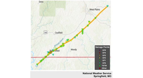
The National Weather Service (NWS) in Springfield has updated its survey of the Bakersfield tornado from March 14 that killed three people in the Ozark County town. Originally one person was listed as injured, but the latest update shows the tornado injured four people. The new update also shows a wider path and a longer track. The NWS used information from their survey team and satellite data to determine the path and strength of the tornado.
The tornado started in Baxter County near Gamaliel just west of Arkansas State Highway 101, then tracked into the town where it damaged the post office and fire station. It then tracked northeast along Highway 101 where it uprooted and snapped numerous trees. Damage continued as the tornado tracked just west of Baxter County Road 43 before it moved into Missouri.

This part of the tornado has been rated an EF1 with winds of 100 mph, but the overall rating of the tornado is EF3 based on damage that occurred in Missouri.
The tornado obtained EF3 intensity with peak winds of 145 mph as it moved through Bakersfield resulting in three fatalities and four injuries. The tornado then continued to the northeast and passed just south of South Fork before causing damage along the portion of Highway 63 that turns southeast as it exits West Plains. The tornado finally lifted along Highway 160 seven miles east of West Plains.
The total tornado path length was 35.74 miles. The path length of the tornado in Missouri was 30.1 miles with 5.64 miles in Arkansas. The maximum width of the tornado was around 1200 yards, up from the estimated 600 yards from the original report.
The tornado destroyed numerous homes and damaged dozens of other homes. Multiple cars were rolled 50 to 100 yards. Numerous trees were also uprooted including entire groves of trees destroyed.
WebReadyTM Powered by WireReady® NSI


