


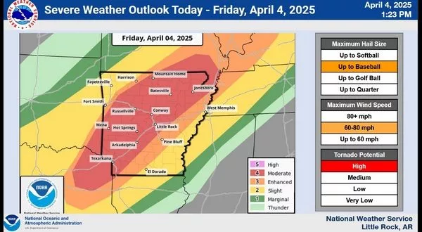
The National Weather Service (NWS) has elevated the risk of severe weather for Friday in the Twin Lakes Area as the area prepares for possible record rain fall amounts through Saturday.
According to NWS Meteorologist Willie Gilmore, a few storms are possible this morning with a chance of large hail. Most of the severe weather is predicted for the afternoon into the evening with some heavy showers and thunderstorms, damaging winds, large hail and possibly a few tornadoes being expected.
Gilmore expects the severe weather to last from 2 p.m. to 8 with heavy rain following.
Extreme rainfall, with an additional 8 to 10 inches possible across parts of the state. This amount of rain
is in addition to what has already fallen. Dangerous and potentially life threatening flash flooding and
river flooding are expected.
The NWS has put us in the highest category for severe widespread flash floods. Areas that don’t normally experience flash flooding could be at greater risk of flooding today.
Stay tuned to KTLO, Classic Hits and The Boot for the latest in severe weather coverage.
WebReadyTM Powered by WireReady® NSI