


Weather patterns are setting up this week to bring a rainy Easter weekend to the Twin Lakes area with the possibility of flooding in low lying areas.
The area has just begun to dry out from flooding rains earlier in the month that saw area rivers and creeks exceed their banks. Earlier this week the Corp of Engineers at Norfork Dam opened spillway gates to release flood water held in the lake.
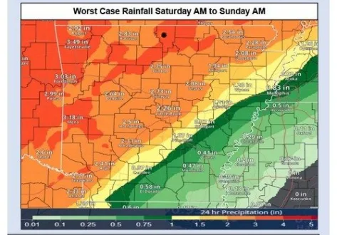
Rain is expected to start Friday and continue through Sunday in multiple rounds of heavy precipitiation with slight risks for severe weather. North Central Arkansas could see upwards of 3 to 5 inches of rain over the 3 day period.
The month has already broken records having landed in the top six wettest Aprils on record with a current total of 10.19 inches. It would take only 2.74 inches of additional rain to land in the top 3. The wettest April on record for Mountain Home is from 1927 when 16.87 inches of rain fell.
Stay tuned to KTLO, Classic Hits and the Boot for the latest in severe weather coverage.
WebReadyTM Powered by WireReady® NSI