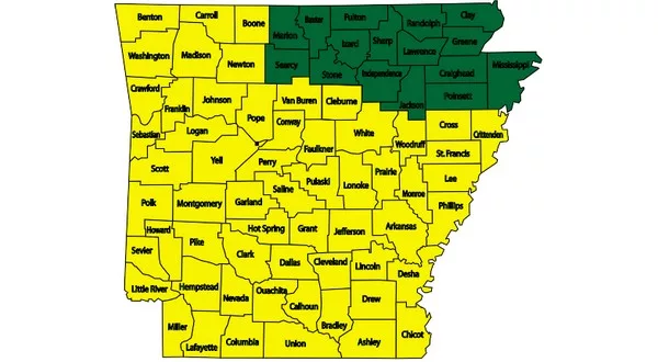
Green – Low wildfire danger; Yellow – Moderate wildfire danger (Image courtesy of Arkansas Department of Agriculture)
Weather wise, August has been a roller coaster of a month. After the first half was unseasonably wet, the brief rainfall on Saturday afternoon was the first measurable precipitation in 13 days, and there were multiple days during that period with triple digit heat index values.
This month is currently on track to finish as the sixth wettest August on record. At KTLO, Classic Hits and The Boot, the official reporting station for the National Weather Service in Mountain Home, the total precipitation for the month so far is 7.39 inches. Most of that rainfall was recorded during a period between Aug. 6 and Aug. 14. No precipitation was recorded for the next 12 days, and only .01 of an inch of measurable rainfall was measured at observation Sunday morning.
The lack of rainfall in the last half of the month has led to concerns about potential drought conditions and wildfire danger. The U.S. Drought Monitor is classifying portions of two area counties as “abnormally dry.” The areas include Fulton County from around Salem to areas further east, northeastern Izard County including Horseshoe Bend and Franklin.
In addition, Howell County has areas from West Plains and continuing east labeled abnormally dry. There are also areas north of West Plains in the category of a moderate drought.
While no portion of the Twin Lakes Area is under a burn ban, there are areas with an increased wildfire danger. Boone and Newton counties are two of 59 counties in Arkansas currently in a moderate wildfire danger by the Arkansas Department of Agriculture’s Forestry Division. The remaining 16 counties of the Natural State considered to be in a low wildfire danger include Baxter, Marion, Fulton, Izard, Searcy and Stone counties.
WebReadyTM Powered by WireReady® NSI


