


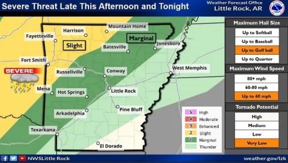
An unsettled pattern will develop starting later in the day on Tuesday, creating conditions for severe weather and heavy rain into the weekend according to a new report from the National Weather Service (NWS). Some strong to severe thunderstorms are possible late Tuesday through Thursday. With the strongest storms, large hail and damaging winds will be the primary threats, with some tornadoes also being possible. Some areas of heavy rainfall will become possible by late this week with multiple rounds of rainfall forecast.
NWS meteorologist John Lewis shares the following Tuesday morning update.
Listen:
Stay tuned to KTLO, Classic Hits and the Boot for the latest in severe weather updates.
WebReadyTM Powered by WireReady® NSI