


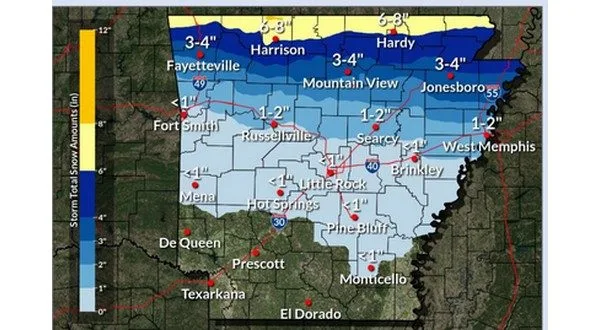
A winter storm warning is in effect for northern Arkansas and the Twin Lakes area from 6 Tuesday to 6 Wednesday, with the National Weather Service warning of heavy snowfall and dangerous cold temperatures in the coming days.
According to the National Weather Service, the storm is expected to bring 4 to 6 inches of snow, with locally higher amounts near the Missouri state line. A light glaze of ice accumulation is also possible.
“Expecting busy weather through most of this coming week, with most eyes focusing on the Tuesday-Wednesday timeframe for a potential winter storm at this point,” said NWS meteorologist Eric Greene. “Impactful snowfall is expected to unfold as early as Tuesday morning, but likely through Tuesday afternoon and into the night through Wednesday morning.”
Snowfall is expected to begin in the region by late Tuesday morning, with complete snow coverage likely by early afternoon. Greene said snowfall rates could quickly lead to accumulations and hazardous travel conditions, particularly near the Arkansas-Missouri border.
“Through the evening, expecting conditions to deteriorate for the most part across much of the Arkansas-Missouri border region with snowfall rates quickly leading to accumulating snowfall and likely deteriorating road conditions and travel possibility,” Greene said.
The snowfall is expected to taper off by early Wednesday morning, but bitterly cold temperatures will follow. Lows on Wednesday morning are expected to drop into the single digits, with wind chill values near or below zero. The coldest temperatures are expected Thursday morning, with actual air temperatures potentially falling below zero and wind chill values between -10 and -15 degrees.
“Very hazardous cold expected Wednesday through Friday morning could easily lead to any type of health problems, frostbite if we are outside in this type of air temperature without any type of proper clothing or protection,” Greene said.
Cold temperatures through the week will mean snowfall will remain through at least the weekend when temperatures begin to rise above the freezing point.
The NWS urges residents to prepare for dangerous travel conditions and extreme cold, ensuring they have adequate winter clothing and emergency supplies. Officials warn that exposure to such conditions can lead to frostbite or hypothermia if proper precautions are not taken.
Plans should be made to limit travel, check on vulnerable neighbors, and ensure pets are kept indoors as the storm approaches.
Stay to KTLO, Classic Hits and The Boot for the latest in winter weather updates, road conditions, and closing and cancellations brought to you by Baxter Health.
WebReadyTM Powered by WireReady® NSI